Calculate Longest Flow Path Using Whitebox Tools (WBT) Plugin in QGIS
Time of concentration (TOC) is an important hydrology parameter which represents the time required for surface runoff to travel from the most hydraulically remote point (normally divide or ridge) in the watershed to the outlet, or the longest flow path. Whitebox Tools (WBT) Plugin in QGIS has the capability to calculate a watershed’s longest flow path.
Before calculating the longest flow path, a watershed should have been delineated using Whitebox Tools (WBT) Plugin in QGIS.
- Run LongestFlowpath of WhiteboxTools Plugin. As shown in Figure 1, the Input DEM File is a filled DEM and the Basins File is the watershed raster file delineated in this instruction.

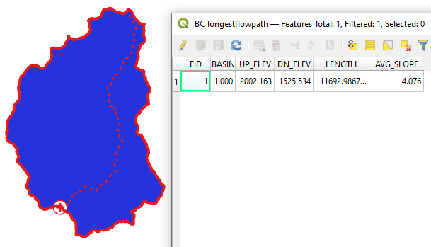
- The longest flow path shapefile created at Step 1 and its attribute table are shown in Figure 2. The attributes of the longest flow path include upstream elevation, downstream elevation, length, and average slope along the path.

- The attributes presented in the longest flow path shapefile can be used to calculate time of concentration (TOC).
Leave a Reply