Geoid, Vertical Datum, Elevation, NAVD88
A Horizontal datum is to measure a location on the Earth’s surface in latitude and longitude or other coordinate systems. A vertical datum is used to measure the elevation or depth relative to a standard origin, such as mean sea level (MSL). Ellipsoids and Datums (such as WGS 84, GRS80, NAD83) have been explained previously and this article is to focus on vertical datum.
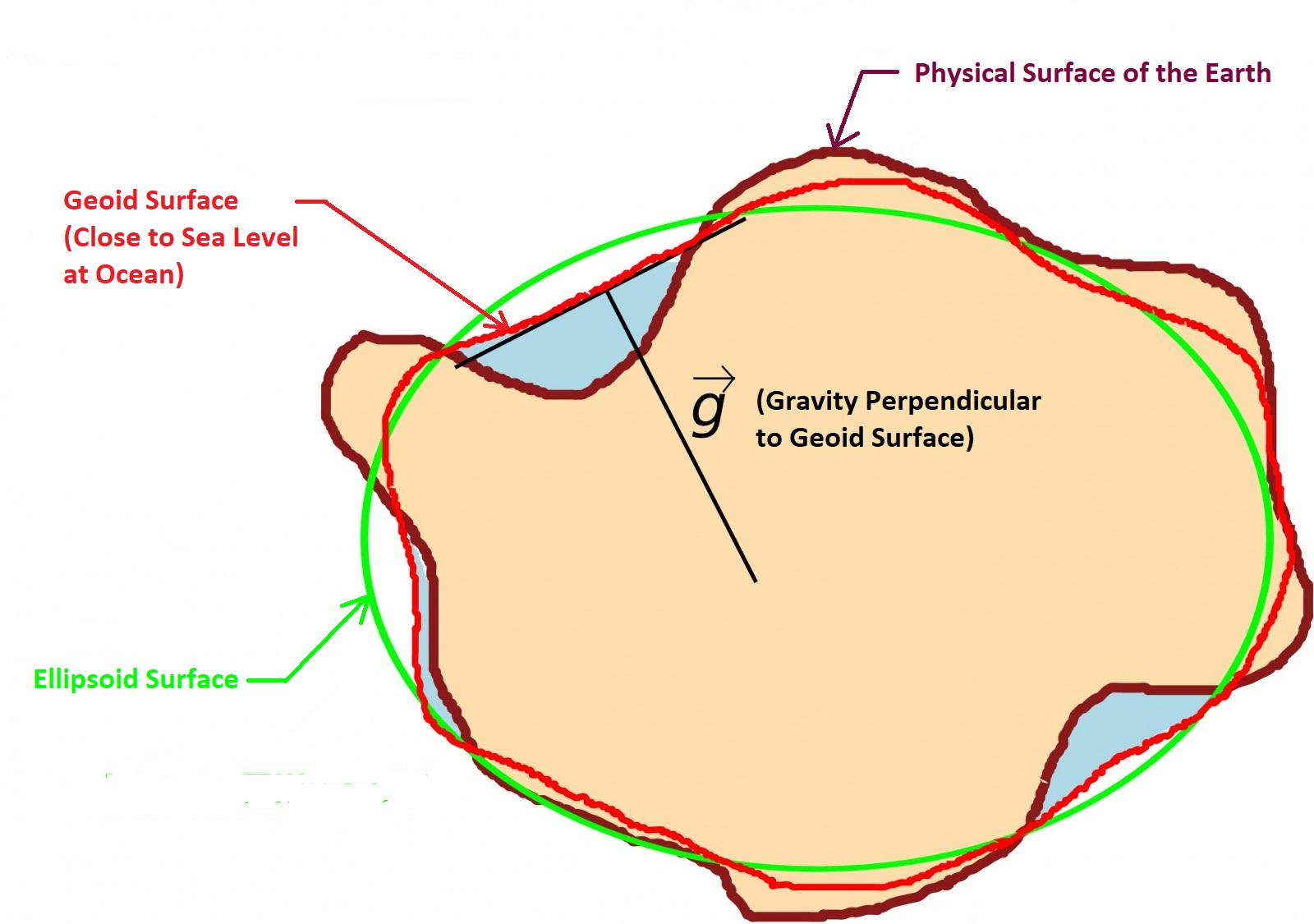
Just like in order to to define a location’s horizontal coordinates you will need to define a horizontal datum first, a vertical datum is required to measure or define elevations. Geoid, an equipotential surface to which the gravity force is everywhere perpendicular, is usually used to define a vertical datum. A plumb line is always perpendicular to the surface of geoid. Unlike ellipsoid which is an idealized representation of the earth, the geoid surface is irregular even though it is still much smoothers than earth physical surface (Figure 1). This is due to the fact that geoid surface is an equipotential surface but the gravitational field of the earth is not uniform thanks to varying density and weight among different geological compositions, mountain ranges, sea trenches, crust compaction due to glaciers, and so on.

Geoid is imaginary and it is realized through measurement and mathematical calculation. Technology advancement, measurements, and mathematical calculation improvements can all contribute to different geoid models. NAVD88 vertical datum is established on the basis of geoid. Per National Geodetic Survey of NOAA, the latest geoid model as of 2021 for NAVD88 is Geoid18 for continental USA, Puerto Rico, and the U.S. Virgin Islands, while Geoid12B should continue to be used for Alaska, Hawaii, Guam and the Commonwealth of the Northern Mariana.

As shown in Figure 2, the elevation in reference to NAVD88 is a type of orthometric height (H) which is measured from geoid surface or zero surface of NAVD88. Orthometric height is different from ellipsoid height (h) and their difference is defined as geoid height (N, negative if geoid surface is beneath ellipsoid, or positive if geoid surface is above ellipsoid. The ellipsoid height (h) can be obtained from GPS and thus it is called GPS ellipsoid height sometimes.
In conterminous USA, the geoid surface is usually beneath the ellipsoid and therefore the geoid heights are negative and the orthometric height (H) is numerically greater than the ellipsoidal height (h) at any given location. Globally, the geoid height (N) ranges from about +75 to -100 meters and in the conterminous USA the geoid height (N) varies from -8 to -53 meters. Figure 3 is an illustration to show the orthometric height (H) is numerically smaller than the ellipsoid height (h) for areas where geoid surface is above ellipsoid.

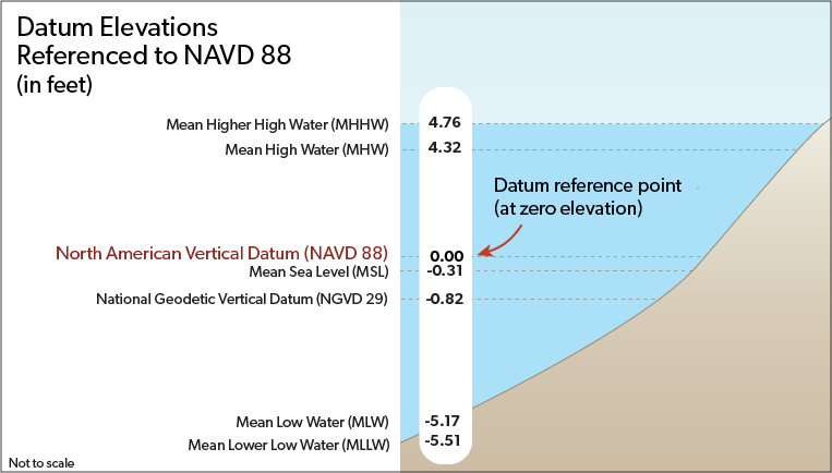
NAVD 88 datum is different from Mean Sea Level (MSL) as illustrated in Figure 4 for NOAA tide gauge station in Boston (station ID 8443970).

Theoretically NAVD 88 datum is based on a type of Geoid models, but in practice it was realized by geodetic leveling starting from a single datum point at Father Point/Rimouski in Quebec, Canada. NAVD 88 datum consists of a leveling network of survey benchmarks on the North American Continent and unfortunately these benchmarks are not well maintained and seldom being replaced when missing. For this reason and other errors found since its establishment, NGS will replace North American Datum of 1983 (NAD 83) and North American Vertical Datum of 1988 (NAVD 88) with four new terrestrial reference frames based on ITRF 2020 and a new geopotential datum based on GEOID2022.
- North American Terrestrial Reference Frame of 2022 (NATRF2022)
- Pacific Terrestrial Reference Frame of 2022 (PATRF2022)
- Caribbean Terrestrial Reference Frame of 2022 (CATRF2022)
- Mariana Reference Frame of 2022 (MATRF2022)
- North American-Pacific Geopotential Datum of 2022 (NAPGD2022), based on GEOID2022, to replace NAVD88
The new reference frames will rely primarily on Global Navigation Satellite Systems (GNSS), such as the Global Positioning System (GPS), as well as on a gravimetric geoid model resulting from the Gravity for the Redefinition of the American Vertical Datum (GRAV-D) Project. These new reference frames are easier to access and maintain than the current NSRS, which relies on physical survey marks that deteriorate over time.
Leave a Reply