Earth, Ellipsoid, Datum, Coordinate Reference System (CRS), and Projection in GIS
Earth is not a perfect globe and its surface is irregular. GIS needs to use coordinates values (X/Y, or Longitude/Latitude) to describe an actual position/feature on earth in software system. To mathematically define a coordinate reference system (CRS) we will need to use a flattened three-dimensional ellipse with smooth surface to approximate the earth, which is called an ellipsoid.
Different ellipsoids (thus different sizes and shapes) can be defined depending on the needs. In Figure 1, the difference between Ellipsoid WGS 84 (or WGS 1984) and Ellipsoid GRS 80 (or GRS 1980) is exaggerated on purpose to highlight the fact that they are different ellipsoids, even though in fact their difference is really negligible (0.1mm, Table 1).


An ellipsoid has different ways to position itself relative to Earth depending on where its center is located, which is called as different realizations. Each realization is called a datum and therefore an ellipsoid may have different datums (Figure 2). A common datum for GRS 80 is NAD83 and a common datum for WGS 84 is WGS 84 (the datum has the same name as its ellipsoid in this case). Google Map, Google Earth, and Global Positioning System (GPS) use WGS84 as the datum. Originally (in the mid-1980s), NAD83 Datum and WGS84 datum were virtually identical, however, today, they are separated by roughly 1 to 2 meters because they anchor to different things: NAD83 datum is pinned to the North American Tectonic Plate while WGS84 datum is tied to earth’s center of mass.

Ellipsoid is different from geoid. Geoid, an equipotential surface to which the gravity force is everywhere perpendicular, is usually used to define a vertical datum. Unlike ellipsoid which is an idealized representation of the earth, the geoid surface is irregular even though it is still much smoothers than earth physical surface.
Since longitude and latitude are in reference to a datum and any location on earth (3D surface) can be defined by longitude and latitude values. This type of CRS is Geographic Coordinate System (unprojected) with coordinate unit of degree.
Another interesting fact is that since longitude and latitude values are tied with datums, a location’s longitude and latitude values in reference to Datum WGS84 are different than in reference to Datum NAD83 (Table 2); however, the difference normally is insignificant: in US, the difference in terms of horizontal distance between WGS 84 and NAD 83 coordinates is around 1.0 meter or 3~4 feet, which can be neglected for most H&H applications.

To represent a point on earth (3D surface) on 2D maps, we use various projection methods to make the conversion (Figure 3). A 3D element will lose at least one of its three characteristics – angle, area, and distance when being projected onto 2D surface, NO MATTER which projection method is used. The coordinate system on 2D surface is called a Projected Coordinate System with coordinate unit of foot (international foot), US survey foot (or US foot), or meter.
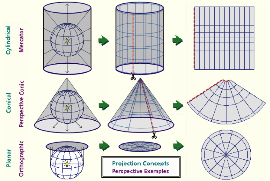
It should be noted that the Cylindrical (Mercator) projection in Figure 3 is not the one used for UTM Zones. UTM Zones use Transverse Mercator Projection which is achieved by rotating the cylinder in Figure 3 by 90 degree (Figure 4).

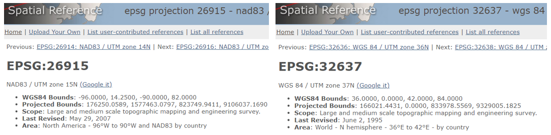
There are two different UTM Zones – UTM Zones (WGS 84) and UTM Zones (NAD83) depending on which datum the UTM zones are based upon. In the United States and North America UTM Zones (NAD83) are popular (for example, EPSG 26915 – UTM Zone 15N), while in the rest of the world you may have a greater chance to work with UTM Zones (WGS 84) (for example, EPSG 32637 – UTM Zone 37N), as shown in Figure 5.
Two common conic projections are Albers Equal Area Conic Projection and Lambert Conformal Conic Projection.
- Albers Equal Area Conic projection is commonly used for large areas which require equal-area representation. USGS uses this projection for maps showing continental 48 US states (EPSG 5070).
- Lambert Conformal Conic is similar to Albers Equal Area Conic Projection, but it’s conformal (preserve angles) rather than equal area. This projection is widely used in the United States for a lot of State Plane Coordinate System (SPCS) when zones are east-west oriented, such as Texas State Plane Coordinate System or Louisiana State Plane Coordinate System.
EPSG Geodetic Parameter Dataset (also EPSG registry) has a coded database of various coordinate systems including Geographic Coordinate Reference System and Projected Coordinate System (https://www.spatialreference.org/). For example, in EPSG dataset, UTM Zone 17N is coded as EPSG 26917 (NAD83 Datum), Texas State Plane Coordinate System South Central Zone is coded as EPSG 2278 (NAD83 Datum), and the Geographic Coordinate Reference System used by Google Earth is coded as EPSG 4326 (WGS84 Datum).
The following are some common CRS:
- EPSG 4326: Geographic Coordinate System, WGS84, used by GPS, Google Earth and some US government agencies for example USDA NRCS web soil survey (Note: web soil survey is different from gSSURGO and gSSURGO uses EPSG 5070); Unit: degree
- EPSG 4269: Geographic Coordinate System, NAD83, used by USGS (National Watershed Boundary Dataset – WBD, for example), FEMA, and U.S. Census Bureau (TIGER/Line); Unit: degree
- EPSG 3857: Projected Coordinate System, WGS84, used by Google Map and some other online map providers including OpenStreetMap; Unit: meter. EPSG 3857 is often referred to as Web Mercator, Google Spherical Mercator, or Popular Visualisation Pseudo-Mercator. Some data source gives out Lat/Long degrees for elements projected to EPSG 3857, instead of X/Y coordinates in meters. These Lat/Long are actually converted from X/Y coordinates using WGS 84 datum and only are presented as Lat/Long degree for convenience purpose. Civil engineering, surveying, and H&H modeling should completely avoid EPSG 3857.
- EPSG 26910 to 26919: Projected Coordinate System, UTM Zone 10N to 19N, NAD83, covering Continental US from west coast to east coast; Unit: meter
- EPSG 2275 to 2279: Projected Coordinate System (Lambert Conformal Conic projection), Texas State Plane Coordinate System, North Zone to South Zone (FIPS 4201 to 4205), NAD83, Unit: US survey foot (Note: Texas State Plane Coordinate System has other EPSG coded systems which use an adjusted NAD83 Datum such as NAD83 2011 which includes EPSG 6582, 6584, 6578, 6588, 6586.
- EPSG 3451 and 3452: Projected Coordinate System (Lambert Conformal Conic projection), Louisiana State Plane Coordinate System, North Zone to South Zone (FIPS 1701 to 1702), NAD83, Unit: US survey foot (ESRI 102681 and 102682 are also for Louisiana State Plane Coordinate System, North Zone to South Zone and they are essentially the same as EPSG 3451 and 3452)
- EPSG 5070: Projected Coordinate System, NAD83, used by gSSURGO; Unit: meter. Some agencies refer to EPSG 5070 as ESRI 102039 since they are the same CRS basically (aka USA Contiguous Albers Equal Area Conic USGS version) – Units: Meter; Datum: NAD83; 1st Standard Parallel: 29º 30’ 0” North; 2nd Standard Parallel: 45º 30’ 0” North; Central Meridian: 96º 0’ 0” West; Latitude of Origin: 23º 0’ 0” North; False Easting: 0.0; False Northing: 0.0.
- EPSG 6350: An updated version of EPSG 5070, EPSG 6350 is in reference to NAD83 2011, though. For some reasons, EPSG 6350 has not gained its popularity.
- ESRI 102003: So close to EPSG 5070 or ESRI 102039 that some literatures mistakenly suggested they are the same projections; however, ESRI 102003 has its latitude of origin at 37.5º instead of 23.0º.
- Standard Hydrologic Grid (SHG) was developed by HEC of USACE and it uses EPSG 5070 or ESRI 102039 as its projected coordinate system and thus SHG is a kind of EPSG 5070. Refer to this post for more information about SHG.
- MMC Standard Coordinate System: USACE Modeling, Mapping, and Consequence Production Center (MMC) uses EPSG 5070 Albers Equal Area Conic projection but with unit of survey foot. A sample shapefile in MMC standard projection can be downloaded here. HEC-HMS Tutorials and Guides has an example project which uses MMC standard projection.
- Albers Conical Equal Area Projection used by Annual NLCD (https://www.mrlc.gov): Projected Coordinate System, similar to EPSG5070 except that it uses WGS84 datum instead of NAD83. It is a type of Albers equal-area conic map projection with the following parameters (AEA WGS84) – Units: Meter; Datum: WGS84; 1st Standard Parallel: 29º 30’ 0” North; 2nd Standard Parallel: 45º 30’ 0” North; Central Meridian: 96º 0’ 0” West; Latitude of Origin: 23º 0’ 0” North; False Easting: 0.0; False Northing: 0.0. Some historical NLCD data (Legacy NLCD) could have been projected to EPSG 5070 using GRS80 datum, but it is believed that MRLC.gov has converted the Legacy NLCD data to Annual NLCD using AEA WGS84 as of 2026.
GIS software like QGIS and ArcGIS can work with geospatial files in different CRS as long as the files are assigned to the correct CRS when being created. When working with files in different CRS, GIS will dynamically convert files to a single CRS which you set up initially (Project CRS) – this is called “projection on the fly”. However, “projection on the fly” will consume CPU and memory resources and slow down the computer. Another way is to re-project the geospatial files in other CRS to the Project CRS in advance, and then import them into the GIS project.
In USA, coordinates can be converted between different CRS using NOAA NGS Coordinate Conversion and Transformation Tool (NCAT). Note that latitudes and longitudes are in reference to NAD83 when being used as inputs to NCAT.
1 COMMENT