HEC-DSS File and HEC-DSSVue – Gridded Data
HEC-DSS, USACE Hydrologic Engineering Center Data Storage System, is a type of database system to store data primarily for hydrologic and hydraulic modeling (*.dss file). HEC-DSSVue is a tool to view, edit, and visualize a HEC-DSS file. Unlike other commercial or open source databases, HEC-DSS is not a relational database: HEC-DSS uses blocks (records) to store data within a HEC-DSS file and each HEC-DSS file can have numerous blocks (records), In addition to time series data and paired data in HEC-DSS, gridded data can also be stored in a HEC-DSS file.
Gridded data usually covers a region to represent spatially distributed data and they are normally imported and stored in a HEC-DSS file in the format of SHG grids, which means the gridded data is projected to EPSG 5070 with grid cell sizes defined by Standard Hydrologic Grid (SHG), either 2000-meter x 2000-meter by default, or other sizes. Refer to this post for more details about SHG. There are usually two types of gridded data in HEC-DSS:
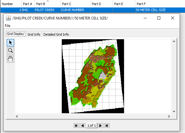
- Static gridded data (or single grid): gridded data is not time dependent, such as a NOAA Atlas 14 precipitation depth grid for a certain AEP, SCS Curve Number grid, or a soil property grid (Figure 1 – a Curve Number grid, the sample dss file can be downloaded here);
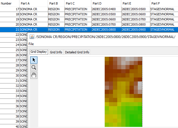
- Time series gridded data, or grid set: one such gridded data record represents an instant value at a time or an average/cumulative value within a single time interval; a set of such records, AKA grid set, represents a time series data over a region (Figure 2 – hourly incremental precipitation data, the sample dss file can be downloaded here).
Similar to time series data or paired data, gridded data in HEC-DSS is also identified by a pathname consisting of six parts, /A/B/C/D/E/F/:
- Part A of gridded data – Grid Reference System: SHG or HRAP or other reference systems;
- Part B of gridded data – Name of the region covered by the grid or the name of a watershed, or a station name;
- Part C of gridded data – data parameter: such as PRECIP or PRECIPITATION for precipitation, ELEVATION for surface elevation, or AIRTEMP for temperature, CURVE NUMBER for SCS curve numbers;
- Part D of gridded data – Starting date and time of the interval. The format is DDMMMYYYY:HHMM. The date:time is in reference to UTC. Thus UTC 25DEC2005:1200 is 6:00 am Dec 25, 2005 of United States Central Standard Time (UTC-6), and UTC 04JUL2006:0200 is 9:00pm July 3, 2006 of United States Central Daylight Saving time (UTC-5). Time 0000 is midnight at the beginning of a day; Part C can be null for a static or single grid.
- Part E of gridded data – For grids representing cumulative or average values over a time interval, Part E means the ending date and time of the interval, using the same date and time formats of Part D. 2400 is the end of a day (midnight). Part E is null for grids of instantaneous values or a static grid.
- Part F of gridded data – Version of the data or a descriptor.
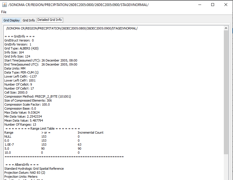
In Figure 2, click the Detailed Grid Info tab in HEC-DSSVue, the grid size, projection system, grid cell location indices, data type, and data unit will display. Per Figure 3, the gridded data is projected to SHG (EPSG 5070, Albers Equal-area Conic Projection, Unit: Meter, NAD83 Datum), the cell size is 2000-meter x 2000-meter, the data type is PER-CUM (Incremental precipitation, or cumulative precipitation falling within a time interval), the precipitation data unit is mm, and the lower left cell indices are (-1137,1001).
Raster files can be imported to HEC-DSS to create static gridded data or grid set for hydrologic and hydraulic modeling purpose. HEC provides several instructions on how to create a gridded data or grid set by importing raster files via Vortex:
- Import a raster CN file via Vortex Importer to create a gridded curve number data in HEC-DSS
- Import Multi-Radar Multi-Sensor (MRMS) Precipitation Data via HEC-HMS to create precipitation gridset in HEC-DSS (Hourly Precipitation Data downloaded from IA State University Mesonet Website )
- Import PRISM precipitation data via HEC-HMS to create precipitation gridset in HEC-DSS (Daily Precipitation Data, from day:1200 to the next day:1200 downloaded from Oregon State University PRISM Climate Data Website)
- Normalizing/Adjusting Hourly Precipitation Data by PRISM Daily Data
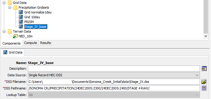
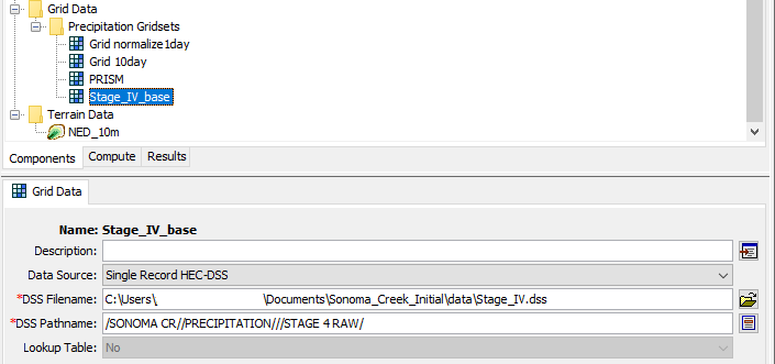
Once gridded data is imported into HEC-DSS, HEC-DSSVue can open, view, or simply edit gridded data. To retrieve gridded data in HEC-HMS, DSS file name and pathname are used. To use the entire time series gridded data set or gridsets in HEC-HMS, the DSS needs to be imported as Grid Data – Precipitation Gridsets. The pathname can be of be any single record’s (Figure 4), or simply use a generalized pathname by leaving Part D and Part E blank (Figure 5).
A meteorologic model can be created by setting its precipitation as “Gridded Precipitation” and use the above precipitation gridsets – refer to this post for more details.
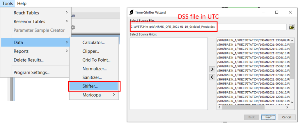
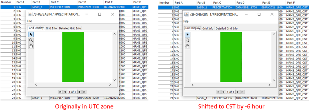
Attention should be paid to the fact that most of the downloaded precipitation radar data in gridded format are originally in reference to Coordinated Universal Time (UTC+00:00) zone, and quite often they need to be shifted to a local time zone. HEC-HMS has a built-in tool of Time Shifter to help complete the task (Figure 6, Figure 7, and Figure 8, using CST as local time zone for illustration). Time Shifter uses -hours to shift to time zones west of UTC+00:00 and +hours for time zones east of UTC+00:00.

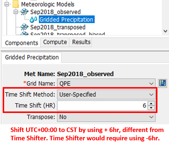
It should be noted that the starting from HEC-HMS V4.10, time shifting of gridded precipitation can be also done when defining a meteorology model as gridded precipitation with Time Shift Method being User-Specified (Figure 9). The positive or negative sign of the time shift hours entered here is the opposite of what Time Shifter would require.
HEC-HMS has the following suggestion on handling time zone misalignment, which seems to suggest that using Time Shifter to make the conversion first is the preferred way (Figure 10).

Leave a Reply